Survey of Bowentown Bar identifies changes in best place to cross
The Tauranga Harbour Master has carried out a survey of the Bowentown Bar area and identified some significant changes to the shape and extent of the outer banks of the bar.
The survey, which was carried out in November, highlights changes that have occurred since last year, and which will affect the routes taken to cross the bar.
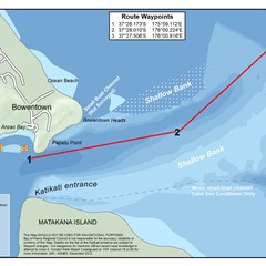
The southernmost route, which passes close to Matakana, has now shoaled and is no longer recommended for use. The two yellow buoys still indicate the best route, although the Harbour Master will be moving the seaward buoy 300-400 m to the SE in order to avoid boats running too close to the northern shoals. Minimum depths of between 2.4-2.6 m can be expected over the outer shoals when using this route.
Jennifer Roberts, Tauranga Harbour Master said the bar is constantly changing so carrying out this survey on a regular basis allows us to make informed recommendations to the public about the safest places to cross.
"With assistance from the local coastguard we will continue to monitor the bar, particularly after storms and heavy rainfall, so we can inform people about any changes and help reduce the risks associated with crossing the bar."
For more information contact the Waihi Beach Coastguard on VHF channel 16 or 85, or phone 07 863 4477.
To download a high resoloution copy of the Bowentown Bar map click here. (1 MB, jpg)