Fiordland quake biggest for 80 years
Thursday 16 July 2009, 12:43PM
By GNS Science
1992 views
The earthquake which struck the Fiordland region last night was the biggest since the Buller and Hawke's Bay earthquakes of 1929 and 1931.
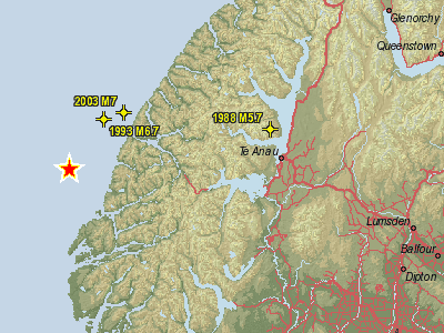
It struck at 9:22 pm, and the epicentre was located in Dusky Sound at the south-west corner of the South Island. Its magnitude of 7.8 makes its size comparable with the Buller (or Murchison) earthquake of 1929 and the damaging Hawke's Bay earthquake of 1931.
Mainshock
- Wednesday, July 15 at 9:22 pm, magnitude 7.8
Main aftershocks to date
- Wednesday, July 15 at 9:41 pm, magnitude 6.1
- Thursday, July 16 at 1:50 am, magnitude 5.9
Reported Damage
No deaths or injuries have been reported.
Cracks in exterior walls were reported from one property in Invercargill, and another at nearby Otatara reported the piles were now distorting their lounge floor. There are also reports of ground slumping causing some property damage in that area. There have been lots of reports of articles falling from shelves and items being ejected from cupboards throughout Southland, as far north as Wanaka and Hawea and east to Dunedin, and isolated reports of power and telephone outages at Gore, Glengarry, Scotts Gap, Orepuki, Otautau, Otatara, Te Anau, Invercargill, Merrivale and Queenstown. A water main was reported to have broken at Winton, north of Invercargill.
Tsunami recordings
A small tsunami was generated by this earthquake, with the tide gauge at Jackson Bay, near Haast, recording a wave of 1 metre (peak to trough). An Australian gauge located out at sea, south-west of New Zealand, also detected a small wave some time after the main earthquake, which may have been generated by a landslip into the sea.
A team of scientists and technicians are visiting the area to carry out observations and install further monitoring equipment to better understand this earthquake and its place in New Zealand's seismological history:
- An overflight of the area is being undertaken this morning to see what damage has happened to the landscape. There are expected to be numerous landslides in Fiordland as a result of this earthquake.
- At least 5 portable seismographs will be deployed in the vicinity of the mainshock. Data recorded by these instruments enable scientists to locate aftershocks more accurately and better understand which part of the crust has ruptured, and how it might affect nearby faults.
- A GPS survey will also be carried out to determine the extent of any movement or uplift in the region.
View 7.8 Earthquake in Fiordland and aftershocks in a larger map
