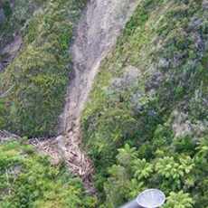
Managing forest debris in storms
Bay of Plenty Regional Council and the forestry industry are looking into reducing the damage caused by forest debris in storms after three major storms in the Bay of Plenty caused considerable damage.
Last week's Regional Council Operations Monitoring and Regulation Committee meeting heard that Ōpōtiki and Whakatāne District Councils, local community and the Regional Council had analysed how to manage the debris issue and recommend how to reduce or avoid future forest debris issues at harvested sites.
Regional Council Manager Land Resources (Eastern) Simon Stokes said the Bay of Plenty had the second highest amount of plantation (exotic) forestry of any region - 50 percent of the productive land. Forestry and wood processing are a key driver industry, contributing about 10 percent of the regional Gross Domestic Product annually (about $1 billion). In the next 10 years, the log harvest in the region is forecast to increase, with a serious increase in harvest operations, he said.
"Most of the 287,000 hectares of exotic forestry is located in catchments east of the Waitahanui River catchment (84 percent), with most in the Rangitāiki River catchment. Economically, forestry and wood processing provides 19 percent of the Eastern Districts' GDP."
The vulnerability of the region's forestry estate to storm events is approximately 25,700 hectares (9 percent) and the most vulnerable landscape is in the Waitahanui, Whakatāne, Ōhiwa, Waioeka and Mōtū/East Coast river catchments. Ninety percent of the exotic forest estate also has identified high risk soil types vulnerable to erosion.
"While forest debris management may appear to be an increasing problem we need to see this in context of the wider benefits that forestry brings to the region both in terms of the economic returns and benefits in reducing erosion on our steeper and more unstable hill country," Mr Stokes said.
The recent storms at the end of 2010 and early 2011 affected the Whakatāne River, Ōhiwa and Nukuhou, Waimana, and Ōpōtiki area river catchments. Where harvesting ofPinus radiatahad occurred within the last five years, the upper catchment areas were the most affected. Most had been replanted, with very steep slopes left to revert to indigenous cover.
"The first storm left the harvested upper catchments relatively unaffected and did not cause much forest debris movement or mass movement erosion. However the landscape was still saturated when the second storm arrived. This high intensity rainfall event, combined with the saturated landscape, created significant issues of forest debris movement and mass movement and fluvial erosion," Mr Stokes said.
The percentage of forest area eroded was relatively small, with about five percent of the total forest area directly affected. The storm was very localised and cut a path about three kilometres wide, he said.
The first noticeable damage was where forest debris was backed up against bridges, culverts, farm fences, heavily wooded native bush or deposited in streams and their floodplains. Forest debris that did flow through was deposited on paddocks, tracks, roadways, estuaries and on beaches.
Capital works and structures were affected, largely within forest estates. An earlier storm removed two walkway bridges and helped to flood and damage several properties in the urban area. Forestry companies and Regional Council staff assisted with the clean-up. Forest industry, Regional Council staff and other technical experts discussed current and future forest practices to reduce or eliminate the movement of forest debris.
Staff are educating the regional forestry sector on high-risk erosion classes of land to enable improved harvest and replanting planning, ultimately removing those slopes and site locations from a harvestable plantation forest land use.
Forest companies are to implement four key on site harvest management practices - removing slash from at-risk sites, burning where practical, poisoning standing trees and establishing slash racks on alluvial plains or planted stands, providing another form of alluvial plain buffer.

