More Tsunami Warning Lines
Tuesday 10 April 2012, 1:15PM
611 views
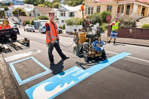
More blue lines - to help communities to safely evacuate if a tsunami is on the way - are to be painted on roads in suburbs around Wellington's south coast and harbour over the next year or so.
Owhiro Bay and Houghton Bay residents will be the first, later this month, to hear about the plan to extend the blue-line project along the south coast. The first blue lines appeared on roads in Island Bay last year and have since successfully raised awareness about the need for residents to be prepared for a tsunami or other emergency.
In the coming year the City Council's emergency management staff will work with communities to educate as many people as possible about their tsunami risk.
The City Council's Emergency Preparedness Manager, Fred Mecoy, says public information presentation evenings will be held over the coming months in 11 coastal areas.
With GNS Science, the Wellington Emergency Management Office will host the first of those presentations in Owhiro Bay School on 17 April and Houghton Valley School on 19 April, both at 7.00pm.
Further presentations, on dates yet to be confirmed, are to be held in Seatoun, Karaka Bays/Maupiua/Breaker Bay, Miramar, Lyall Bay/ Kilbirnie/Rongotai, Haitaitai/Roseneath/Oriental Bay, Mt Victoria/Mt Cook, the CBD, Thorndon/ Pipitea and Makara.
Mr Mecoy says Wellington Emergency Management Office (WEMO) staff have been working with GNS Science and Greater Wellington Regional Council to draft the proposed locations of new blue warning lines on streets around the south coast and harbour. Generally, the lines would be marked on roads at or near 35 metres above sea level.
He says this is the maximum tsunami 'run-up' height expected to be possible in a local 'worst case scenario'.
"Luckily for most people living on the coast and the harbour, there are big hills nearby. The challenge we have is to make as many people as possible in these locations fully aware about what they have to do if there's a big earthquake. If you feel a quake that makes it difficult or impossible to stand up and/or it continues for a minute or more, don't wait around - head for higher ground."
Dr Graham Leonard, a natural hazard scientist at GNS Science, says because of Wellington's position on the boundary between two tectonic plates, the area has in the past experienced tsunami and is likely to again at any time.
"There's a likelihood a big quake could occur under the sea in Cook Strait or nearby - and if a tsunami has been generated, it could hit our coast and harbour in only a matter of minutes."
Mr Mecoy says the presentations aim also to show people the best evacuation routes in their neighbourhoods. Residents will also be able to discuss other possible warning signage and solutions - and the presentations will provide an opportunity for communities to strengthen their local networks and emergency plans.
Wellington's first blue tsunami lines were introduced to Island Bay in a pilot programme last February. The concept has since generated positive interest from overseas including the United States Federal Emergency Management Agency (FEMA), Pacific Tsunami Warning Centre and the Cabinet Office for Disaster Management in Japan.
In preparation for the Blue Lines project, WEMO has posted information about tsunami preparedness on its Facebook site:
Facebook.com/WemoNZ (click on the Tsunami Safe Zone icon)