7.8 quake in Fiordland and 6.1 aftershock
Wednesday 15 July 2009, 9:55PM
6125 views
Infonews editor Fraser Mills described the earthquake, as felt from Wanaka, as a "long rolling quake" which "shook doors, rattled cupboards" and the house he was in.
please see the earthquakes page on newszealand for ongoing updates from GeoNet and Pacific Tsunami Warning Center
- New Zealand Earthquake Report - Jul 15 2009 at 9:22 pm (NZST).
Magnitude 6.6, Wednesday, July 15 2009 at 9:22 pm (NZST), 90 km north-west of Tuatapere.
- New Zealand Earthquake Report - Jul 15 2009 at 9:22 pm (NZST)
Magnitude 7.8, Wednesday, July 15 2009 at 9:22 pm (NZST), 100 km north-west of Tuatapere.
After shocks have been recorded by GNS
- New Zealand Earthquake Report - Jul 15 2009 at 9:41 pm (NZST)
Magnitude 6.1, Wednesday, July 15 2009 at 9:41 pm (NZST), 150 km west of Tuatapere.
- New Zealand Earthquake Report - Jul 16 2009 at 1:50 am (NZST)
Magnitude 5.9, Thursday, July 16 2009 at 1:50 am (NZST), 120 km north-west of Tuatapere.
No tsunami threat to New Zealand
A small tsunami of 0.17m was recorded at Jackson Bay. Based on that information the potential threat warning is now lifted.
No further tsunami threat exists for New Zealand coastlines as a result of the 7.8 earthquake that occurred near Tuatapere today at 2123 NZST.
Fiordland quake “a good shake” - Civil Defence Emergency Management Group
Tonight’s Fiordland earthquake gave the Southland region “a good shake” but was not particularly damaging, according to Southland Civil Defence Emergency Management Controller Neil Cruickshank. Mr Cruickshank said that the region’s Emergency Operations Centre had monitored the situation throughout the evening and would continue follow up work in the morning. “Invercargill reports that phone services were down in east Invercargill and power was out for some time in the suburb of Otatara because of the earthquake. “Southland District Council reports that in the Milford and Te Anau areas there were no reports of substantial damage and the infrastructure in those areas appears to be working well. Inquiries are continuing to assess damage around the Tuatapere area.” Mr Cruickshank said there had been conflicting reports of the size, depth and location of the earthquake from the various monitoring agencies. A tsunami warning had been issued and Southland Civil Defence Emergency Management had monitored sea levels through people and equipment stationed at Bluff. A .17m tsunami had been detected at Jackson Bay on the West Coast and the tsunami warning had subsequently been cancelled, he said. Mr Cruickshank said that in the morning Environment Southland staff, in co-operation with other agencies, would begin air reconnaissance in the morning to check for landslides in Fiordland. The region’s substantial roading network, particularly state highways and bridges, and remote DOC huts would also be checked as a precaution. No further media releases will be issued tonight. Contact Michele Poole, Public Information Manager Southland CDEMG 021 784 964 Or Eirwen Tulett, Public Information Manager 027 293 8680 Wednesday 15 July 2009, 11.45pm
MEASUREMENTS OR REPORTS OF TSUNAMI WAVE ACTIVITY
GAUGE LOCATION LAT LON TIME AMPL PER
------------------- ----- ------ ----- --------------- -----
Jackson Bay, NZ 43.97S 168.62E 10:18Z 0.17M 10min
DART Tasman Sea, NZ -46.92S 160.56E 09:53Z 0.05M 8min
LAT - LATITUDE (N-NORTH, S-SOUTH)
LON - LONGITUDE (E-EAST, W-WEST)
TIME - TIME OF THE MEASUREMENT (Z IS UTC IS GREENWICH TIME)
AMPL - TSUNAMI AMPLITUDE MEASURED RELATIVE TO NORMAL SEA LEVEL.
IT IS ...NOT... CREST-TO-TROUGH WAVE HEIGHT.
VALUES ARE GIVEN IN BOTH METERS(M) AND FEET(FT).
PER - PERIOD OF TIME IN MINUTES(MIN) FROM ONE WAVE TO THE NEXT.
Joint Australian Tsunami Warning Centre have issued a warning for Lord Howe Island
For low-lying coastal areas there is a threat of MAJOR LAND INUNDATION,
FLOODING, DANGEROUS WAVES AND STRONG OCEAN CURRENTS for several hours from
09:30 pm (EST) Wednesday.
People in affected areas are strongly advised by the NSW STATE EMERGENCY SERVICE
to go to higher ground or at least one kilometre inland.
For all threatened areas, people are advised to get out of the water and move
away from the immediate water’s edge.
Next update will be issued by 10:07 PM EST on Wednesday 15 July 2009
Below is a map and the initial reports availble online.
View 7.8 Earthquake in Fiordland and aftershocks in a larger map
GNS Science - report
New Zealand Earthquake Report - Jul 15 2009 at 9:22 pm (NZST).
Magnitude 6.6, Wednesday, July 15 2009 at 9:22 pm (NZST), 90 km north-west of Tuatapere.
Quake Details
Information about this earthquake:
Reference Number 3124785/G
Universal Time July 15 2009 at 9:22
NZ Standard Time Wednesday, July 15 2009 at 9:22 pm
Latitude, Longitude 45.78°S, 166.68°E
Focal Depth 5 km
Richter magnitude 6.6
Region Fiordland
Location
90 km north-west of Tuatapere
90 km south-west of Te Anau
150 km north-west of Invercargill
300 km west of Dunedin
Felt in souther South Island.
http://www.geonet.org.nz/earthquake/quakes/latest.html
New Zealand Earthquake Report - Jul 15 2009 at 9:22 pm (NZST)
Magnitude 7.8, Wednesday, July 15 2009 at 9:22 pm (NZST), 100 km north-west of Tuatapere.
Quake Details
Information about this earthquake:
Reference Number 3124785/G
Universal Time July 15 2009 at 9:22
NZ Standard Time Wednesday, July 15 2009 at 9:22 pm
Latitude, Longitude 45.75°S, 166.58°E
Focal Depth 12 km
Moment magnitude 7.8
Region Fiordland
Location
100 km north-west of Tuatapere
100 km south-west of Te Anau
160 km north-west of Invercargill
300 km west of Dunedin
This is an update for the earlier posted earthquake. Note the change in magnitude. This earthquake was widely felt in the South Island and as far north as Taranaki.
US Geological Survey is reporting 7.8
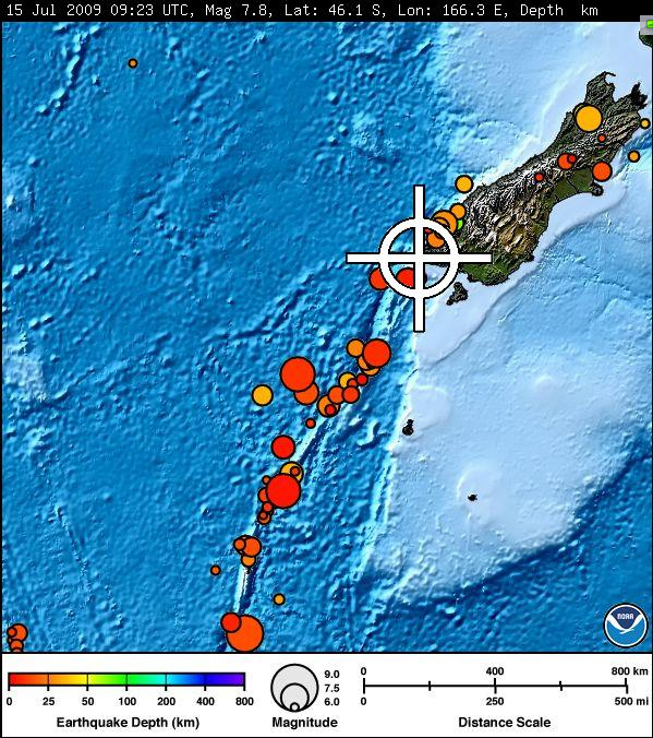
Magnitude 7.8 - OFF WEST COAST OF THE SOUTH ISLAND, N.Z.
Magnitude7.8 (Preliminary magnitude — update expected within 15 minutes)
Date-Time Wednesday, July 15, 2009 at 09:22:33 UTC Wednesday, July 15, 2009 at 08:22:33 PM at epicenter
Location 46.100°S, 166.300°E
View Larger Map
Depth 33 km (20.5 miles) set by location program
Region OFF WEST COAST OF THE SOUTH ISLAND, N.Z.
Distances
161 km (100 miles) W (281°) from Invercargill, New Zealand
219 km (136 miles) WSW (237°) from Queenstown, New Zealand
326 km (202 miles) W (264°) from Dunedin, New Zealand
866 km (538 miles) SW (229°) from WELLINGTON, New Zealand
Location Uncertainty
Error estimate not available
Parameters
NST=037, Nph=037, Dmin=319.2 km, Rmss=1.46 sec, Gp= 65°,
M-type="moment" magnitude from initial P wave (tsuboi method) (Mi/Mwp), Version=1
Source West Coast and Alaska Tsunami Warning Center/NOAA/NWS
Event IDat00764975
An after shock has been recorded by GNS
New Zealand Earthquake Report - Jul 15 2009 at 9:41 pm (NZST)
Magnitude 6.1, Wednesday, July 15 2009 at 9:41 pm (NZST), 150 km west of Tuatapere.
Quake Details
Information about this earthquake:
Reference Number 3124792/G
Universal Time July 15 2009 at 9:41
NZ Standard Time Wednesday, July 15 2009 at 9:41 pm
Latitude, Longitude 46.17°S, 165.79°E
Focal Depth 5 km
Richter magnitude 6.1
Region SW of New Zealand
Location
150 km west of Tuatapere
170 km west of Otautau
200 km west of Invercargill
370 km west of Dunedin
Felt southern South Island, aftershock of event at 9.22 pm