Ongoing monitoring of groundwater post-earthquake.

Environment Canterbury is continuing to monitor groundwater levels in the areas most affected by the September 4 earthquake and providing advice and information to farmers, groundwater consultants and members of the public.
“We recorded quite marked but short-term spikes in groundwater levels in areas close to the earthquake epicentre,” said Ken Taylor, Director of Investigations and Monitoring at Environment Canterbury.
“The groundwater spike effect appears to be related to consolidation of the aquifer material – gravel, sand and silt – and the level of most wells stabilised a week or so after the main earthquake.
“There is no evidence so far of any long-term effect on groundwater levels resulting from the earthquake and aftershocks.”
“Since the earthquake we have provided lots of advice and information to members of the public and farmers on the changes to surface water and groundwater patterns, including the appearance of new springs and changes to river flows.
“Farmers and consultants have also been asking for advice on whether planned aquifer tests should proceed given the potential damage to wells from the earthquake.”
Environment Canterbury is part of the Civil Defence/Selwyn District Council Rural Recovery Group which is helping farmers and rural communities recover from the effects of the September 4 earthquake and aftershocks.
Environment Canterbury is also working with groundwater consultants to investigate one well in the Burnham area which had significant well-yield losses following the earthquake.
The results of this work, when completed, will be provided to the Irrigation NZ taskforce operating as part of the Rural Recovery Group, which is providing advice and support to well operators and irrigators.
Environment Canterbury’s groundwater investigations programme
Environment Canterbury staff manually measured groundwater levels around the region in the week following the earthquake. As a result Environment Canterbury’s scientists now have a preliminary understanding of the earthquake’s effects on the groundwater system. In addition to the manually recorded data there was preliminary data from telemetered recorders and data downloaded from a number of other recorders.
Environment Canterbury will continue to measure groundwater levels and provide ‘snapshots’ of the effects from the earthquake and aftershocks every two weeks or so.
A greater understanding of the effects of the earthquake will continue to be developed as more data from wells around the region is downloaded and analysed.
The recorders measure groundwater levels at intervals of 15 minutes and provide a higher resolution aquifer response to the earthquake event than relying on manual readings alone.
Effects by groundwater zone
Christchurch-West Melton
Most of the measured groundwater wells have above average to high groundwater levels for this time of year.
Preliminary groundwater level data has been analysed from two recorder sites following the earthquake. One well had an immediate spike of 1m and the level gradually recovered to its initial level over a period of four days.
The other recorder site had a spike of 4m and recovered to a level 1m higher than pre-earthquake after a period of six days. The preliminary assessment is that observed spikes are likely to be localised and temporary responses to consolidation of the aquifer.
Abnormal groundwater levels were observed in two wells both of which dropped by approximately 1m following the earthquake.
Selwyn-Waihora
Groundwater levels in this zone were within their average to above-average range for this time of year prior to the earthquake. Six out of eight recorders downloaded so far show an obvious spiking in water level as a response to the earthquake with levels stabilising within a week.
For four wells groundwater levels have returned to pre-earthquake levels and the two remaining have stabilised to within 0.3m of their pre-earthquake level. The observed spikes are likely to be local responses to consolidation of the aquifer. Some well owners have reported that their wells produced cloudy water for a few days which then cleared.
In the vicinity of Irwell/Doyleston, recorder data from a cluster of wells with depths of 9, 24, and 68 metres showed an initial spike in water levels in the two deeper wells immediately following the earthquake. The recorder in the shallowest well did not show a response. Water levels have now returned to within 0.3m of pre-earthquake levels.
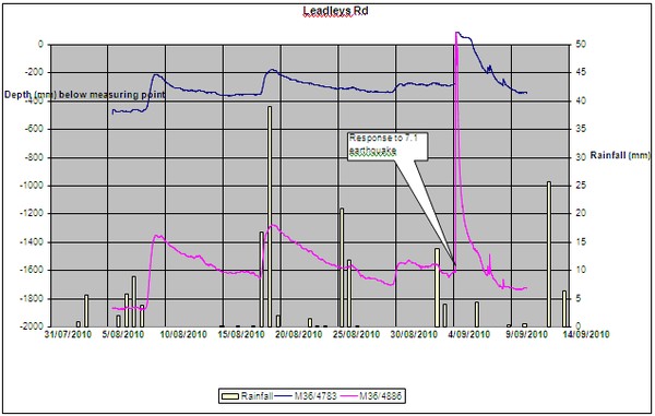
Figure A is an example record from data recorders near Ladbrooks. Fifteen minute data from water level recorders in wells M36/4783 (21.5 m deep) and M36/4886 (9 m deep) show that shallow groundwater levels rose by between 0.4 and 1.5 m in response to the earthquake. The levels have subsequently fallen and stabilised to approximately the level seen prior to the earthquake.
Ashburton
Groundwater levels in all wells are near maxima for this time of year.
There were short-term spikes in groundwater levels in a small sub-set of wells. This spike coincided with the occurrence of the earthquake and a majority of wells are stabilising to expected levels for this time of year.
For the second month that groundwater levels are above average in most wells south of the Ashburton River. There is no evidence to indicate that the groundwater levels have been permanently altered as a result of the earthquake. These preliminary interpretations will be verified as more recorder and manual data become available.
Waimakariri
With the exception of two wells, the groundwater levels were either similar to or slightly higher than in August.
Water levels in M35/0472 (24 m deep) and M35/0538 (12 m deep) dropped by approximately 1m in comparison to August’s levels. Both of these wells are located about 2 km from the coastline and both readings are the lowest recorded in a 30 year period. It is uncertain why these two wells have responded so differently from the remainder of the network. These wells will be monitoring more frequently to assess their condition and determine whether the wells have been damaged or the aquifer is responding to the earthquake.
Hurunui-Waiau
There has been a slight increase in groundwater levels of between 0.1m and 2m since the previous set of measurements taken in August, which is consistent with seasonal trends.
No significant changes to groundwater levels are expected in this basin because of its distance from the epicentre. This analysis will be confirmed once the recorder data is processed.
Upper Waitaki and Lower Waitaki- South Canterbury
No water levels have been collected yet in these areas and it is unlikely the September 4 earthquake will affect groundwater levels because of the distance from the epicentre.
Orari-Opihi-Pareora
The wells regularly monitored in this area have not shown a direct response to the earthquake. This is not surprising because this part of the region is distant from the epicentre.
Groundwater levels have continued on the general trend seen prior to the earthquake, with levels still average to high for this time of year throughout the region.
Kaikoura
Because of a landslip that closed SH 1 until Thursday, the monitoring of this area will be done this week.