NIWA: Scientists set to delve into the secrets of the Cook Strait mega-canyon

Targeted geological sampling and imaging by NIWA scientists next week will help understand active seabed processes in one of New Zealand’s largest seafloor features.
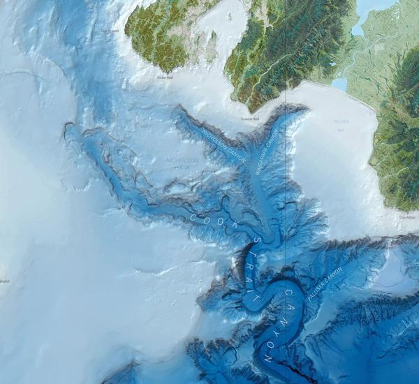
Cook Strait Canyon starts just 10 kilometres off the coast in 50 metre water depths and plunges to 3000 metres south of Cape Palliser. The canyon, one of the largest in the world, is scarred by numerous large submarine landslides and active faults. Despite its size and proximity to the capital very little is known about the events that have shaped this canyon and the hazards they may pose.
This week, scientists led by NIWA Marine Geologist Dr Joshu Mountjoy will use a new dynamic positioning (DP) system onboard NIWA’s research vessel Tangaroa to collect sediment cores, rock samples and DTIS (deep-towed imaging system) footage of the seafloor. The DP system uses electrically powered thrusters and computerised controls to fix the vessel to a specific area, guided by satellite positioning or transponders on the seabed. It will allow the scientists to take very accurate samples from the canyon floor, landslide scars and fault scarps, in 500-1,000 metre depths.
Data collected will provide information about active sediment transport through the canyon, how often landslides and earthquakes occur, and give scientists a first glimpse of the biology in the canyon.
“This voyage is a step towards understanding one of New Zealand’s most remarkable seafloor features. Internationally, mega-scale canyon systems like Cook Strait are regarded as the focus of deep ocean sedimentary activity. We know that dramatic sediment movement occurs through much of Cook Strait in response to tide related currents but we have no information on the canyon system. It is really exciting to be on the verge of collecting the first images and samples from this extraordinary landscape – including the first footage of the biology living in these canyons,” says Joshu.
“Data collected will also help us to quantify hazards that could be created by landslides and earthquakes in the canyon system, ensuring New Zealand is better prepared to respond to natural disasters in the future. Landslides in the canyon are huge, up to four times the size of Wellington’s Mount Victoria, and have the potential to generate hazardous tsunami.
“We need to know two things - one is to understand how often they occur and the other is to model the tsunami generation potential. This voyage will provide information on how often the landslides happen, while NIWA and GNS Science are working together under the Natural Hazards Research Platform to quantify the tsunami generation potential.”
While there are several canyon systems in New Zealand, Cook Strait Canyon is one of the largest and the closest to any major city. NIWA has mapped more than 150 individual landslides throughout the Cook Strait canyon system, ranging in volume from 2.5 million cubic metres to approximately ten cubic kilometres. Understanding the causes and recurrence of these landslides is part of a long-term goal of quantifying the landslide tsunami risk to New Zealand’s coastal communities.
The research is funded by the Ministry of Science and Innovation under the “Consequences of Earth Ocean Change and Impacts of Resource Use on Vulnerable Deep Sea Communities” programmes, and through the Natural Hazards Research Platform.