Tsunami threat to New Zealand: Marine threat confirmed

A tsunami marine warning is in effect for New Zealand:
The tsunami warning will remain in effect until a cancellation message is issued by MCDEM.
An earthquake has occurred with these parameters:
|
Origin time: |
0545Z 11 March 2011 |
|
NZ time: |
1846NZDT 11 March 2011 |
|
Co-ordinates: |
38.2 North 142.5 East |
|
Depth: |
24km |
|
Location: |
Near East Coast of Honshu, Japan |
|
Magnitude: |
8.9 |
The above magnitude is provisional and may be increased or decreased as more seismic data becomes available.
Summary:
Bay of Plenty Civil Defence Emergency Management Group has activated and is monitoring the situation.
The Pacific Tsunami Warning Centre (PTWC) has issued a Tsunami Warning for New Zealand in response to the above earthquake. Confirmation has been received that a tsunami was generated. Wave heights of up to 4 metres have been measured in coastal Japan. Wave heights of 0.2 m have been observed in Nauru and Honiara.
First arrivals have been measured by coastal gauges at the New Zealand coast. At Raoul Island Kermadecs first arrival was recorded at 0635 hours today and at North Cape at 0710 hours. Initial wave amplitudes are in the order of 15cm. It is important to note that higher wave amplitudes are expected to follow in the next few hours based on modelling.
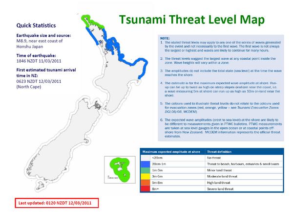
The New Zealand Tsunami Expert Panel assessment is that there is a marine and minor land threat only for parts of the upper North Island coasts of New Zealand. See the attached threat level map and threat zone table for further details. The Green and Blue shaded areas on the map indicate where a minor land and marine threat exists, respectively.
The New Zealand Tsunami Expert Panel assessment is that there is a marine and minor land threat only for parts of the upper North Island coasts of New Zealand.
Based on real-time tsunami modelling and comparison with historical events, the interpretation is that a minor land threat (i.e. wave heights just over 1 m) now exists in Northland between Ahipara and the Karikari Peninsula as well as in the Bay of Islands and the Chatham Islands. A minor land threat means there is a small potential for impacts on beaches in these areas. A marine threat (i.e. threat to the coastal marine area and small boats) remains in place for the northern North Island from Kaipara to Ahipara and south of the Karikari Peninsula to Gisborne. Unusual tidal surges may be observed in other parts of the country.
Passage of the wave through the South Pacific has been observed. Wave heights observed in the Pacific islands confirm the current threat assessment for New Zealand.
The first wave to arrive to New Zealand was calculated to be in the area around North Cape at approximately 0623NZDT 12 March 2011. Monitoring of the propagation of the tsunami across the Pacific indicates that actual arrival times may be an hour later or more than the modelled times published below.
A tsunami is a series of waves or surges and the first wave may arrive later and may not be the largest. The largest arrivals are anticipated from about 0800 NZDT and expected to last for several (at least five) hours. Tsunami activity such as unusual currents and changes in sea-level will continue for several hours after first arrivals. Tsunami wave heights cannot be accurately predicted and can vary significantly along a coast due to local effects.
Only messages issued by MCDEM represent the official warning status for New Zealand. Local civil defence authorities may supplement these messages by applying local threat assessments.
People in coastal areas should:
1. Stay off beaches
2. Stay out of the water (sea, rivers and estuaries, including boating activities)
3. Do not go sightseeing
4. Share this information with family, neighbours and friends
5. Listen to the radio and/or TV for updates
6. Follow instructions of your local Civil Defence authorities.
MCDEM and scientific advisors are closely monitoring the situation to determine the severity of the threat to New Zealand.
Bay of Plenty Civil Defence Emergency Management Group information
Bay of Plenty Civil Defence Emergency Management Group has activated and is monitoring the situation.
The expected arrival time in the Bay of Plenty is about 7.20am
The Whakatāne River Bar has been declared unworkable.
Update for Tauranga and Western Bay
A marine threat still remains in place for the Bay of Plenty.
A wave of approximately half a metre is the most likely scenario – arriving between 8.00am and 2pm. The marine threat affects beaches, estuaries and the sea by causing strong and unusual currents and unusual wave activity.
The Surf Life Saving Championship organisers have been advised of this threat and will be updated every 30 mins, or as required, as more information comes to hand.
Boating activities can be hazardous in these situations and so recreational and fishing boats, in particular, are advised not to be undertaken until the threat is lifted.
All boat ramps are staffed this morning to advise people of the warnings.
People in coastal areas should:
1. Stay off beaches
2. Stay out of the water (sea, rivers and estuaries, including boating activities)
3. Do not go sightseeing
4. Share this information with family, neighbours and friends
5. Listen to the radio and/or TV for updates
6. Follow instructions of your local Civil Defence authorities.