Exclusion zone around Rena reduced
In consultation with the appropriate authorities, Bay of Plenty Regional Council's Harbourmaster has directed that the exclusion zone around the MV Rena be reduced to two nautical miles.
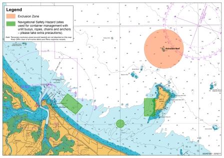
Download a high resolution map of the exclusion zone below.
The exclusion zone ensures that the Rena response operations can continue safely, without hindrance from other vessels. It is also intended to keep vessels away from areas that are known to contain navigational safety hazards such as containers and debris from the Rena.
The exclusion zone is regularly reviewed in conjunction with the Maritime New Zealand, who lead the response operations.
Anyone found in the exclusion zone without the express permission of the Harbourmaster may be prosecuted.
Vessel operators are reminded that additional temporary exclusion zones require them to stay at least 200 metres clear of any beached or floating containers from the Rena, as well as any salvage vessel working on the response.
Vessel operators are also reminded to take extra care around any anchored containers and the three anchoring sites, used for corralling containers in the water. These areas may contain unlit buoys, ropes, chains and anchors, so people should keep well clear. These sites are east of Rabbit Island (Motuotau Island), off the western side of Mōtītī Island and off the coast of Pāpāmoa Beach.
People are advised to check the Bay of Plenty Regional Council website or contact local marine radio operators to find out the latest information.
Please notify Maritime New Zealand if you see oil or containers in the water by calling 0800 645 774.