Powerful 7.4 quake hits New Zealand's South Island
Saturday 4 September 2010, 7:12AM
2689 views
.jpg)
A powerful 7.4-magnitude earthquake woke Canterbury early this morning.
No tsunami alert was issued and there were no reports of injuries.
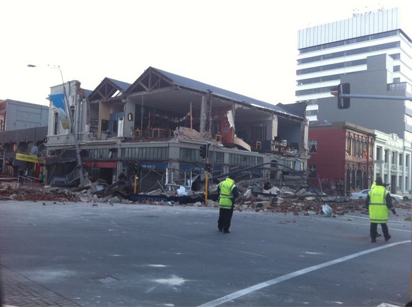
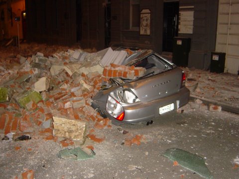
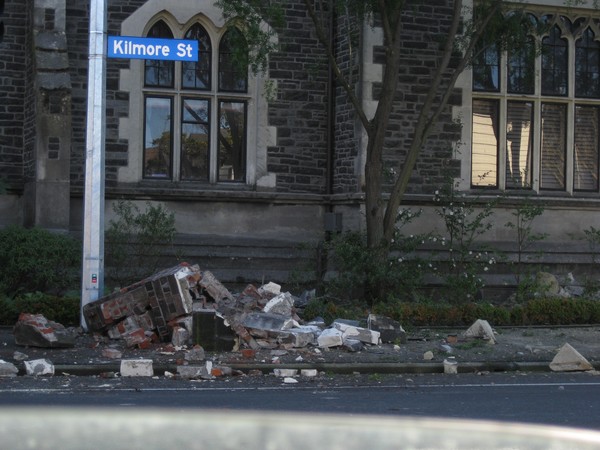
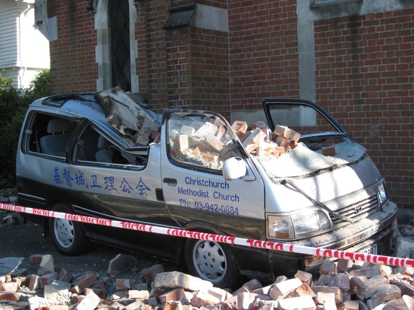
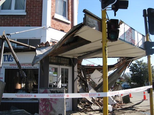
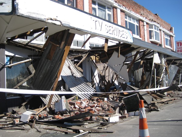
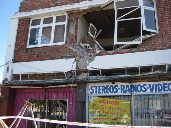
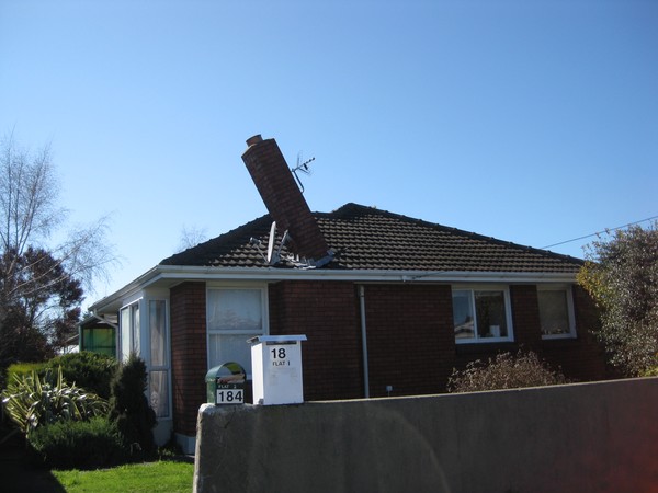
The quake, which hit 30 kilometers west of Christchurch, destroyed buildings and cut power and phone lines.
Christchurch police reported some road damage in parts of the city.
There was also a series of sharp aftershocks.
Police have cordoned off some streets where rubble was strewn about from the quake.
Photos and reports of building damage are emerging on twitter (#eqnz) and the Civil Defence are doing damage assessments now.
Some of the earliest pics have come from http://twitpic.com/photos/five15design from @five15design
A Christchurch resident told infonews the earthquake felt like the largest they had experienced and there had been significant aftershocks. One of which struck while talking on the phone.
See an Interactive map showing information and instrument recordings about the earthquake and felt reports submitted by people from different localities. on the GeoNet website
Quick Facts:
- The quake occurred at 4.35am at a depth of 33 kilometres
- There have been several aftershocks; magnitude 4.6, 3.9 and 4.3
- Power is off and from the Rakaia River to the Waimakariri River
- Heavy Damage has been reported to Geo Net across Canterbury
- Many Roads are damaged and closed
- Some water lines have been damaged
- Some sewer pipes are also damaged
- Airport Closed
- Some phone lines are down.
Sewer and water lines have been ruptured and some substations have been badly damaged and are offline.
Christchurch City Council is recommending people stay off the roads and to conserver water while damage assessments are being done.
Most of the damage reports coming in are for Brick buildings and damage is visible on every street with chimneys collapsed all over the city according to a Cashmere resident who spoke to infonews.co.nz this morning.
Christchurch police have cordoned off parts of Avonside Drive which they say is now un-drive able.
Christchurch hospitals are operational and there have been no major injuries reported to them so far.
Civil Defence Headquarters has activated the national crisis centre. No tsunami warning has been issued.
Christchurch Civil Defence say police have shut down the central city streets due to fallen debris and for safety.
Christchurch Airport has closed and may re-open after 10am. People with travel plans are being advised not to come to the airport this morning according to Airport staff.
Canterbury Civil Defence advised all Metro bus services are suspended until further notice.
Update
All Selwyn residents are being asked to conserve water, but especially in Rolleston. Rolleston water supply is contaminated. Minimise water use, e.g. flushing toilets.
Christchurch hospital is functioning however is running on generator power.
All State highway structures are currently open to traffic.
Lyttleton Tunnel has been checked and reopened.
Ashley River Bridge: has had initial check by structural engineer and is currently available for traffic.
Only current closure is on SH74 on the ring route around Christchurch. The road is closed at Bromley due to major road deformation.
New Zealand Earthquake Report - Sep 4 2010 at 4:35 am (NZST)
CANTERBURY
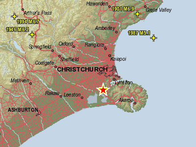
Magnitude 7.4, Saturday, September 4 2010 at 4:35 am (NZST), 30 km west of Christchurch.
Quake Details
Information about this earthquake:
Reference Number 3366146/G
Universal Time September 3 2010 at 16:35
NZ Standard Time Saturday, September 4 2010 at 4:35 am
Latitude, Longitude 43.54°S, 172.23°E
Focal Depth 33 km
Richter magnitude 7.4
Region Canterbury
Location
10 km south-east of Darfield
20 km east of Coalgate
30 km west of Christchurch
Widely felt throughout New Zealand.
Did you feel this earthquake? We would appreciate it if you could fill out a GeoNet Felt Earthquake Report and let us know of your experiences.